
Planning Season Is Here: Do You Have the Full Picture?
As utilities enter planning season, having a clear, current view of network conditions is essential for prioritizing risk, allocat…
Every day, organizations responsible for critical infrastructure make decisions that affect millions of lives. They manage risk, maintain reliability, and protect the systems communities depend on.
Yet too often, those decisions are made using incomplete or outdated information.
For years, organizations have been forced to compromise between speed, resolution, scale, and cost. Wide-area coverage lacked detail. High-resolution data was slow to acquire and difficult to scale. The complete picture was often out of reach.
At IO Aerospace™, we believed there was a better way.
Founded in 2022 and headquartered in Calgary, Alberta, with Global operations, IO Aerospace™ was created to redefine geospatial intelligence around a simple idea:
What if organizations no longer had to choose?
Our vision was to deliver network-wide visibility with the clarity of airborne imagery, the scale of satellites, and the speed required for real-world decision-making.
To make that vision a reality, we developed a proprietary high-altitude imaging system paired with a purpose-built Learjet 35 platform, creating a solution capable of capturing ultra-high-resolution imagery across vast geographic areas faster and more efficiently than traditional approaches.
Today, IO Aerospace™ helps utilities, governments, emergency managers, and infrastructure owners gain a current, network-wide understanding of the environments they operate in. Through a combination of advanced aircraft services, proprietary sensor systems, and deep engineering expertise, we provide the intelligence organizations need to see more, understand more, and act faster.
Speed. Clarity. Scale.
These principles guide everything we do.
Because as infrastructure networks become more complex and risks continue to evolve, organizations need more than data. They need confidence. They need certainty. They need a trusted source of truth.
We enable rapid, scalable collection of ultra-high-resolution geospatial data across large and complex environments.
Our purpose-built airborne platform delivers 10 cm RGB and NIR imagery, along with precise elevation data, giving organizations the clarity, accuracy, and coverage needed to monitor, analyze, and act with confidence.
By capturing both RGB and NIR imagery at scale, we help organizations develop a current, high-fidelity view of the assets and environments they depend on every day.
At 10 cm resolution, details come into focus.
From infrastructure conditions and surface changes to vegetation health and environmental impacts, our data provides the level of clarity and timeliness required for informed decision-making.
We enable:
With fast turnaround times and cloud-ready delivery, organizations gain access to current, analysis-ready data exactly when they need it.
IO Aerospace™ is built on a commitment to delivering high-resolution geospatial intelligence faster, at scale, and with greater operational flexibility. Our leadership team brings deep expertise across aerospace, engineering, data systems, and communications, driving innovation in how large, complex environments are captured, analyzed and delivered.
Together, they are advancing a more responsive and efficient approach to geospatial data collection through purpose-built aircraft, scalable technologies, and streamlined workflows designed for real-world application.

Jonathan Neufeld
B.Sc., P.Eng., MBA
President
.png)
Trevor Miller
B.Sc., P.Eng.
Chief Technology Officer

Marvin R. Keyser
Vice President of Aircraft Operations

Mark Davis
SVP, Strategic Solutions

Gertrud Riegler
PhD
Director of Product Management

Darrin Keyser
Director of Maintenance

Bronagh Doherty
Director of Finance

Sonia Taylor Crichton
Director of Marketing
High-resolution, wide-area imagery delivered with speed and flexibility.
Contact IO Aerospace™ to learn more about our capabilities or to request evaluation data.
Contact Us
As utilities enter planning season, having a clear, current view of network conditions is essential for prioritizing risk, allocat…

Behind every successful aerial mission is a team of experts who transform complex client requirements into safe, efficient, and ex…
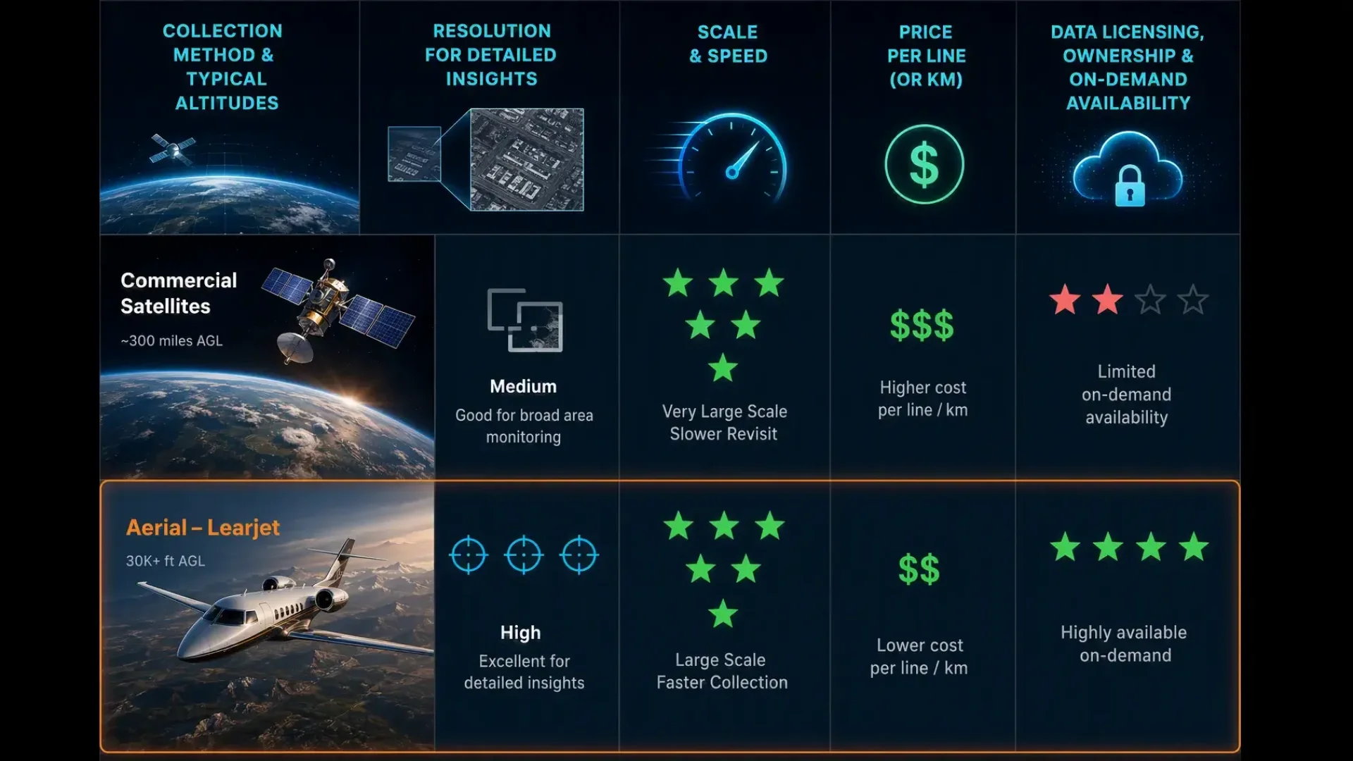
Satellite imagery and aerial imagery serve different purposes, especially for utilities managing vegetation near power lines. Sate…