Five years ago, if you had asked us about the future of airborne remote sensing, we would have told you that drones and satellites were poised to dominate the market from both ends. Satellites, capable of flying high and staying up permanently, can capture vast amounts of data. Drone technology, advancing rapidly, continues to make significant strides in imaging. However, despite these advancements, we are seeing a continued demand for aircraft-based image data collection, and we believe this is for several compelling reasons.
The Limitations of Satellites Create a Need for Airborne Solutions
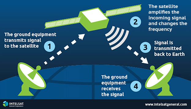
Satellites excel at capturing data from hard-to-reach locations, including remote areas and regions within enemy territory. Their high altitude and permanent presence allow for extensive data capture over large areas. However, there are limitations. The cost of launching and maintaining satellites is prohibitive, and their flexibility is limited. Additionally, the downlink bandwidth is often a bottleneck, reducing the volume of data that can be transmitted back to Earth.
Regulations are Holding Drone Technology Back (A Little)
Drones are fantastic for covering very small areas with super high resolution. They have revolutionized imaging in sectors such as agriculture, construction, and environmental monitoring. However, drones are not without their constraints. They are cost-effective only for small-scale projects and face significant regulatory and technological hurdles, especially regarding operations beyond visual line of sight (BVLOS). While advancements are being made, it is likely more than ten years away from mainstream adoption.
Embracing Satellite Adoption Presents New Avenues for Airborne Operations
Aircraft are uniquely capable of carrying new and advancing sensors, making them ideal for testing prototype payloads. It is less risky and more cost-effective to test new technology in an aircraft than to launch it into space. Moreover, aircraft offer flexibility that neither satellites nor drones can match. They can adjust flight paths based on weather conditions and can be rapidly deployed to capture data on short notice.
Complementary Nature of Aircraft and Satellite Data Acquisition
Aircraft data acquisition is complementary to satellite data acquisition. In a tipping and cueing approach, satellites can identify areas of interest, and aircraft can then zoom in to capture high-resolution data. This integration of data collection methods enhances the overall quality and utility of the data, providing comprehensive insights for various applications.
There is a Sweet Spot for Aircraft-Based Remote Sensing
Aircraft occupy a crucial middle ground in remote sensing, offering extensive coverage at good resolution, which neither satellites nor drones can fully match. They provide cost-effective, wide-area data collection, surpassing satellites in affordability and drones in effectiveness over large areas. This balance of coverage, resolution, and cost-efficiency makes aircraft indispensable for many remote sensing needs. As technology advances, the role of aircraft in remote sensing will continue to grow, driven by the increasing demand for comprehensive, high-quality data.