In today’s highly competitive remote sensing market, it’s easy to get swept up in flashy marketing tactics that promise the “highest resolution” satellite imagery. Today we’re going to pull back the curtain and offer a candid look at how optical satellite imagery is often oversold – and why airborne data acquisition is still the gold standard for high-precision applications.
The Satellite Industry’s Marketing Playbook: Spatial Resolution Hype
Satellite companies love to highlight their panchromatic resolution, making bold claims about image sharpness. They’ll tell you about spatial resolutions as fine as 15 or 30 cm, and showcase these numbers next to stunning, full-color images. But what’s often hidden in the fine print is that this sharp resolution only applies to black-and-white (panchromatic) images, not the color (multispectral) images that most users rely on.
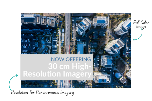
The most detailed commercial optical satellite images currently available offer a panchromatic resolution of approximately 30 cm, but their multispectral resolution (the one capturing actual color data) is closer to 1.2 meters. This difference in resolution is often glossed over in marketing materials. The panchromatic and multispectral images are typically combined in a process called pan-sharpening, which gives the appearance of a sharper color image, but it’s not quite the full story.
Here’s the kicker: satellite companies know that most non-technical users don’t pay attention to this difference. So, they’ll keep pushing those panchromatic numbers, making it seem like they offer color images at a resolution far higher than what’s actually possible. The result? A misleading picture of what you’re really getting when you invest in imagery.
Apples and Oranges: Comparing Satellite to Airborne Imagery
One of the satellite industry’s favorite tricks is to compare their high-resolution satellite imagery to airborne data acquisition, implying that the two are on the same playing field. This couldn’t be further from the truth.
Even the best satellite systems, boasting 30 cm panchromatic resolution, deliver multispectral imagery at around 1.2 meters. In contrast, airborne systems can offer multispectral resolution at 10 cm or better—an enormous difference when precision matters. Whether it’s detailed agriculture applications, infrastructure planning, or environmental monitoring, aerial imagery delivers the kind of clarity and detail that satellites simply can’t match.
Yet, satellite providers often present their products as a one-size-fits-all solution, enticing customers with the promise of “high resolution” without fully explaining what that means for their specific use cases.
Don’t Be Fooled by Marketing Spin: Know What You’re Paying For
It’s time to cut through the marketing noise. The satellite industry has perfected the art of using impressive numbers to sell their products, at IO Aerospace, we’re more interested in delivering what works for you. We don’t just want you to have data; we want you to have the right data for your applications.
That’s why we advocate for more transparent, user-friendly specifications. We make sure our customers fully understand what each product offers, and how factors like spectral resolution and detail affect the results they can expect. There’s no “one-size-fits-all” solution, and we’re here to guide you to the best fit for your mission.

Real Results: Why Airborne Data Acquisition Wins
At the end of the day, no amount of slick marketing can change the fact that airborne imagery outperforms optical satellite data when it comes to high-resolution, precise data collection.
We’ve supported projects across industries, delivering the kind of clarity and detail that helps our clients make better decisions – and faster. Whether it’s monitoring critical infrastructure, managing agricultural landscapes, or planning urban development, airborne data delivers unparalleled results.
Conclusion: Informed Choices Lead to Better Outcomes
When it comes to remote sensing, don’t let flashy marketing sway your decisions. Take the time to understand what you really need—and what you’re really getting. We’re committed to helping our clients cut through the hype and find the right solution for their unique needs.
In a world where marketing spin can cloud the truth, we believe in delivering the facts. Our mission is to provide more than just data—we deliver knowledge, insight, and the kind of high-resolution imagery that drives real-world results.
When you’re ready for clarity, both in your data and in your decisions, IO Aerospace is here to deliver. Reach out to start the conversation.