Addressing methane emissions is vital to fighting the climate crisis.
Currently, there are a handful of methane-aware assets in space. However, they lack precision and detail as they only offer a “zoomed out” perspective of these emissions.
There are also aircrafts designed to fly over methane emitting sites which provide more precision, but they only provide a “zoomed in” perspective. However, the Environmental Defense Fund (EDF) is working to change that. MethaneSAT, a wholly owned subsidiary of EDF, is looking to measure methane with high precision across a wide area. It is dedicated to addressing these emissions through the development, launch, and operations of a satellite.
The satellite is currently being designed and built by Ball Aerospace and Blue Canyon Technologies. It will be capable of tracking and monitoring methane emissions with more precision and accuracy than ever before. The satellite is roughly the size of a small refrigerator and outfitted with two spectral sensors. Using spectrometer technology and inversion modelling the satellite will break white light into a spectrum, revealing the fingerprints of molecules in the air. This aids scientists in determining where a plume of methane is coming from and how much could be emitted.
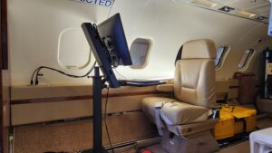
To support the technology development for the satellite, MethaneSAT has first launched MethaneAIR – a special mission to test the satellite sensor technology prior to launch. IO Aerospace is supporting the MethaneAIR mission by providing flight operations and specialized geospatial and airborne remote sensing knowledge. We’re also carrying the MethaneAIR payload on our Special Missions Platform designed for high altitude remote-sensor testing.

When it comes to acquiring methane emissions data, one of the consistent issues is scale. Existing methane detecting platforms struggle to capture and map large areas with precision and accuracy. However, the IO aircraft is specifically modified for special missions, such as MethaneAIR. It has been equipped with unique capabilities that allow the aircraft to fly at higher altitudes for longer sustained periods. Each MethaneAIR flight will cover significant ground and map up to 10,000 km2 per flight. Additionally, the IO team has developed expertise in airborne remote sensing at scale, having mapped over 20 countries across three continents and millions of square kilometers, this experience allows IO to scale missions of all types, including MethaneAIR.
MethaneSAT is seeking more precise data and their satellite will have 200 x 200 km targeting field, allowing for more accuracy in detail from large to tiny variations between points. This is crucial in understanding methane emissions. They come from a range of sources, including the extraction and transportation of fossil fuels. Both the MethaneAIR Mission and MethaneSAT satellite are focused on these emissions.
The modifications to the IO jet have given us the ability to customize each mission. This allows us to effectively test the sensor technology while delivering the reliable, accurate, and high-quality data needed for the MethaneAIR mission. The MethaneAIR Mission will aid in the further development and testing of the MethaneSAT algorithm helping to inform and augment the orbital data collected from the satellite.