Mapping or Monitoring: Which Mission Fits Your Needs?

Share This Post

mapping or monitoring io aerospace

We work with clients on many mission profiles, and one of the common questions we ask at the start is: Are you mapping, or are you monitoring? There are some key differences between mapping and monitoring that have big impacts on your mission design and data processing pipeline. When planning a mission, we consider the required area, frequency of data collection, and the level of urgency. Here, we’ll outline the characteristics of each with insights from the work we do at IO Aerospace.  

What do we consider a ‘mission’? A mission refers to a specialized operation where we deploy our aircraft to achieve specific objectives, such as collecting geospatial data, conducting surveillance, or performing environmental monitoring. These missions are carefully planned and executed to meet the precise goals and requirements set by our clients.  

Mapping Missions 

Mapping missions aim to provide comprehensive representations of geographic areas, including the depiction of natural and man-made features and objects. Here are the defining features of these missions that we would consider when designing your aerial acquisition.   

Wide Area Coverage:

Mapping missions are designed to efficiently cover extensive territories. By operating at high altitudes with our Learjet, our missions maximize the sensor’s swath, enabling data collection over vast areas. This is essential for creating detailed maps for urban planning, environmental management, and infrastructure development applications. Imagine a city that is tracking the urban sprawl of the metropolitan area, they would require wide coverage to see where industrial zones are or how traffic patterns are affected. 

One-Pass Data Collection:

The objective of mapping is to gather all necessary data in a single flight, which is made possible with our Learjet 35 as we can fly for up to 5 hours at a time. This ensures an efficient and systematic data collection process, reducing the need to cover the area (because everyone’s goal is to save money, right?).  

Lower Urgency:

Mapping missions generally involve less urgency compared to monitoring missions. They focus on slowly changing features, such as topography or infrastructure, making them less time sensitive. For instance, creating a land classification map of a region to study different types of vegetation, soil types, and land use patterns is a task that can be planned without immediate time constraints.  

Monitoring Missions 

In contrast, monitoring missions are designed to observe specific areas and detect changes over time. They focus on tracking and assessing variations, trends, and dynamics within the area of interest. The cadence of recurring data collection depends on the objects, features and characteristics to be monitored. Here are their key characteristics: 

Targeted Areas:

Monitoring missions focus on specific areas of interest, such as industrial sites, environmental disasters, or security-sensitive locations. The goal is to observe and detect changes within these targeted areas to implement mitigation measures. For example the NASA’s Oceans Melting Greenland mission tracks the melting rate by comparing data from multiple visits over several years.  

Credit: NASA’s Oceans Melting Greenland Mission

Repeat Visits: 

Monitoring missions require multiple visits to the exact and sometimes remote location(s) to capture changes over time. This enables the detection of temporal variations and the assessment of dynamic conditions. Example: Monitoring methane emissions for an oil & gas facility with an ongoing leak requires frequent and targeted data collection to detect the leak’s source, measure emission levels, and assess the effectiveness of mitigation efforts. 

copyright methane sat imagery

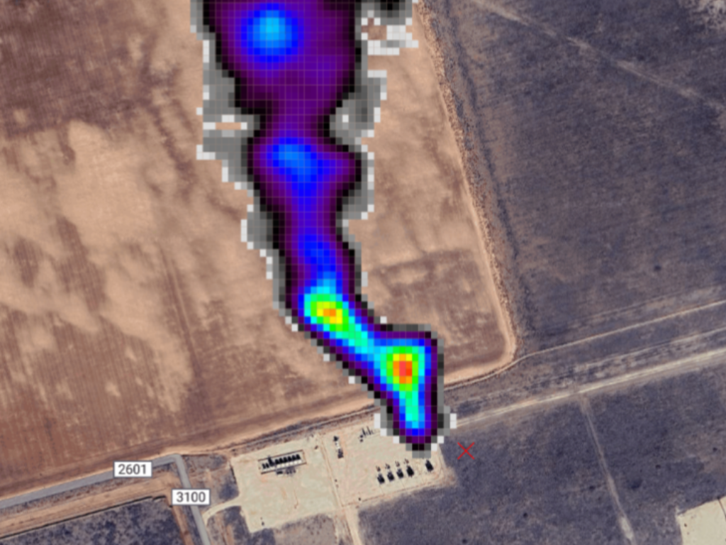
Estimated Leak: 2432 kg/hour | Credit: MethaneSAT’s Methane Monitoring Project 

High Urgency:

Monitoring missions are often driven by the need to detect and respond to rapidly changing situations. Frequent trips and multiple passes are essential to ensure timely data collection and analysis, especially when providing data for a natural disaster like a wildfire or flood.

What’s Your Mission?

As technology evolves, the capabilities of sensors and data processing techniques continue to improve, driving demand for both mapping and monitoring missions. Advanced technologies such as high-resolution satellites, planes, drones, and machine learning algorithms enhance our ability to effectively collect and analyze geospatial data.

Whether your objective is to create comprehensive maps or to track changes over time, tailoring your approach to the specific requirements of each mission type ensures success. At IO Aerospace, we leverage our expertise and cutting-edge remote sensing technology to support a wide range of geospatial missions, helping our clients achieve their goals efficiently and effectively.

Share This Post

More To Explore