When it comes to aerial surveys, choosing the right aircraft can make all the difference in terms of coverage, efficiency, and cost-effectiveness. While piston airplanes have long been a staple for such missions, there is a compelling case for embracing the Learjet, particularly for wide area coverage.
The key to the Learjet’s superiority lies in its much larger footprint. Flying at a higher altitude, the Learjet generates a ground footprint that is a remarkable 10 times larger than that of an unpressurized piston aircraft. This translates to significantly wider coverage. To put it in perspective, one flight with the Learjet can cover the same area as 10 flights on a typical piston airplane, highlighting the remarkable efficiency and scale that the Learjet brings to aerial survey missions.
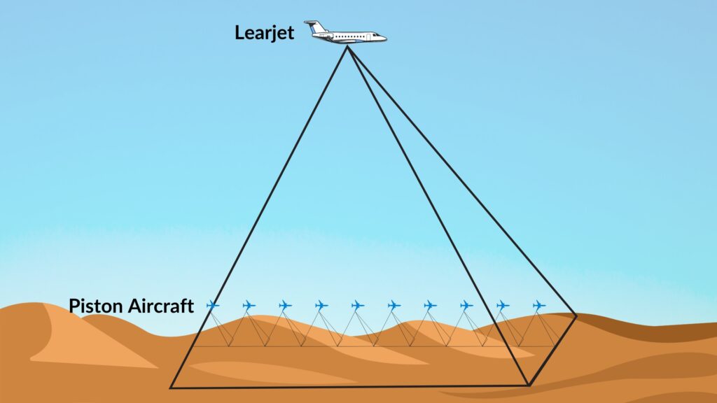
One of the most noteworthy advantages of using a Learjet is the substantial reduction in cost per square kilometer. Although the upfront cost of flying a Learjet may seem higher compared to a piston aircraft, the efficiency gains become apparent when you factor in the massive areas covered in the same timeframe. The cost-effectiveness of the Learjet becomes even more evident when you consider the reduced operational hours and fuel consumption required to achieve the same coverage as a piston airplane.
In essence, a modified and aerial survey capable Learjet proves to be a strategic investment for organizations prioritizing wide area coverage. By optimizing efficiency through its expansive footprint and high speed, the Learjet enables businesses to conduct wide area surveys faster and more efficiently. As the demand for wide area and high revisit imagery grows, a modified Learjet emerges as a clear choice for those aiming to maximize coverage and manage costs.
Despite piston aircraft offering higher resolution images, it is crucial to note that super-resolution imagery is not necessary for all projects. The lower resolution achieved at higher altitudes is compensated for by the ability to capture large areas quickly, making it the ideal choice when the focus is on comprehensive coverage rather than extremely detailed imagery. This trade-off between resolution and coverage further underscores Learjet’s suitability for optimizing resources in large-scale aerial surveys.
In essence, the Learjet excels in efficiency and cost-effectiveness while striking a strategic balance between resolution and practicality in wide-area data acquisition.